Feb. 1-7: First of five 2018 sales from map-centric Old World Auctions
- by Thomas C. McKinney
Highlights from Old World Auctions' ongoing sale
This month we have the first of five sales in 2018 being hosted by online-only auction house Old World Auctions. With cartography as the house’s focus, 784 lots of maps, atlases, and other rarities are coming to auction during Auction No. 166 running now to February 7th. Running in descending order of estimated value, I’ll be highlighting five lots of varying age and subject.
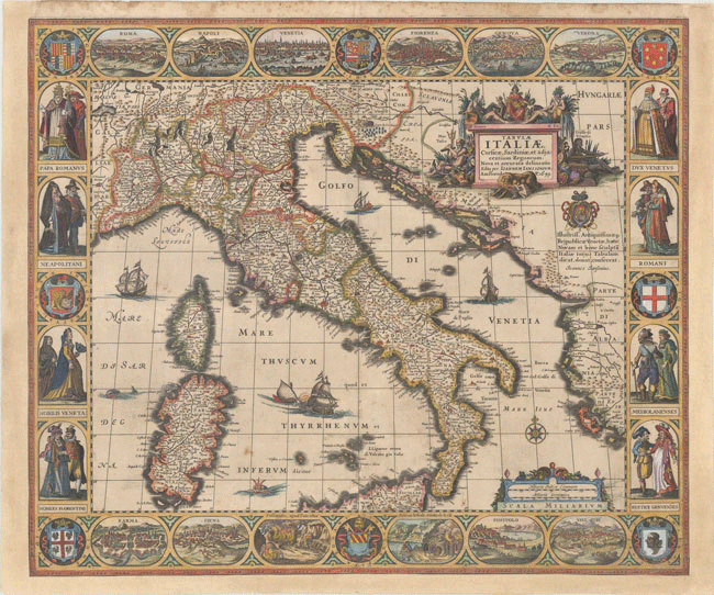
Beginning with a 1659 map of Italy by Hondius entitled “Tabulae Italiae, Corsicae, Sardiniae, et Adjacentium Regnorum, Nova et Accurata Delineatio,” this map first appeared in Jansson’s Atlantis Maioris Appendix of 1630 and then later in two editions of his Newer Atlas. This is a reprint, being clearly dated 1659. It stands out as a highly decorated representation of Italy, surrounded on all sides by engravings of cities and citizens of Rome, Naples, Venice, Florence, Milan, and Genoa, as well as several coats of arms. Listed as lot 571, this map of Italy is estimated $5,500 to $6,500.
Maybe more modern or less serious maps are more your fancy? Look no further than lot 121, a set of two maps from 1944 by Edward McCandish entitled “Bill Whiffletree’s Ration Map of U.S.” and “Bill Whiffletree’s Bootleggers’ Map of the United States.” Both are humorous and quite rare. The Ration Map is a satirical view of the strict consumption laws put in place by the U.S. government in 1942 in an effort to provide a supply line for troops in Europe and Asia. The Bootlegger’s Map is a reprint of the original 1926 version, and this edition was reissued with the Ration Map to make for a set reflecting the humor and mood of the country during these periods of restrictive government policy. The two maps are estimated together $3,000 to $4,000 and have not been seen at auction in over 30 years.
Preceding the McCandish maps by only a few decades, lot 34 is of a totally different nature. A very large, double-hemispheric, thematic map of the world, this “Missionary Map of the World Showing the Prevailing Religions of Its Various Nations and the Central Stations of All Protestant Missionary Societies” was made in 1906 and is descended from the first missionary map made by Joseph Hutchins Colton in the 1840s. Printed on four joined sheets of linen, it measures 80.1 x 44.4 inches and is estimated $2,000 to $2,500.
Returning to the 17th century, lot 455 is a rare, decorative bird’s-eye plan of Amsterdam depicting the city during its Golden Age as one of Europe’s main trading hubs. Entitled “Amstelodamum, Celebre Emporium Forma Plana,” the work includes a depiction of city hall as well as a vignette of the city’s port. Estimated $1,800 to $2,200, an example has not been found in dealer listings or auction records for several decades.
Our last highlight is not a map, but a broadside depicting the Battle of Porto Bello between the British and Spain during the War of Jenkins’ Ear (which itself was a part of the War of the Austrian Succession). On the history of the battle, Old World writes:
After taking part in a failed attempt to capture a fully laden Spanish treasure ship departing from Portobelo in 1727, Vice Admiral Edward Vernon made claims that he could capture the historic port with just six ships. In November 1739, Vernon organized a squadron of six ships to capture the settlement. Due to strong easterly winds, Vernon was initially forced to focus his efforts on the harbor fort (here labeled The Iron Castle). The British caught the Spanish off guard and quickly gained control, forcing the Spanish to surrender the fort. Subsequently, Vernon shifted his efforts to the town of Portobelo, resulting in Spanish surrender of the port. The capture of Portobelo was seen as a big triumph in Britain and America, and the names Portobelo and Vernon were used in commemoration (including Portobelo Road in London, the Portobelo district of Edinburgh, and Mount Vernon in Virginia, the home of George Washington). The British occupied Portobelo for only three weeks, destroying the fortress and key buildings before withdrawing.
The broadside of Porto Bello is estimated $1,800 to $2,000 as lot 328.
Old World Auctions’ Auction No. 166 is running now until Wednesday, February 7th. The catalog is available online here and a smaller list of featured items can be viewed here. Past customers of Old World can sign in with their existing details and new bidders can register here.